Avannaarsua (Nordgrønland)
77°27,855'N 069°11,934'W - Kort 3210
Avannaarsua (North Greenland)
77°27,855'N 069°11,934'W - Chart 3210
By
586 indbyggere (2026)
City
586 inhabitants (2026)
der ejes af Grønlands Selvstyre og administreres af KNI Pilersuisoq A/S, består af en ankerplads ud for byen. Tæt under land findes en lang stenrøse, der er tør ved lavvande. Afhængig af tidevandet kan pramme sejle gennem hullet i stenrøsen til landingssted på stranden. Gennemsejlingen kan benyttes ca. 3½ time på hver side af højvandet.
Bundforhold: Ankerplads: Klippe/ral. Landingssted: Sand/ral.
Qaanaaq betyder "eroderet hule i is eller i land".
Qaanaaq (Thule) er fangerkulturens nordligste by og den traditionelle grønlandske livsform udfolder sig i dag i en forholdsvis "moderne" by, for da den amerikanske luftbase i Thule (også kaldet Dundas) skulle udvides i 1953, blev de oprindelige indbyggere flyttet ca. 130 km mod nord, hvor en hel ny by Qaanaaq (Thule) blev anlagt.
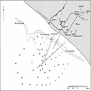
Se havneskitse.
Til ankers:
Længde 135 m, bredde 16,0 m, dybgang 7,0 m.
HW-konstant + 30 min på North Star Bay.
Flodhøjde ved springtid ca. 3,0 m,
ved niptid ca. 1,7 m. Maks. flodhøjde ca. 3,4 m.
Under rolige vindforhold er tidevandsstrømmen WNW-gående 1-3 knob på ankerpladsen og kraftigst fra 3-1 time før højvande. Ved gennemsejlingen til landingsstedet sætter tidevandsstrømmen med 1-3 knob ved stigende og faldende vande.
Vinterisen lukker normalt for besejlingen fra ultimo september til primo juli.
Der vil ofte være kraftig isgang på ankerpladsen, men det er sjældent nødvendigt at flytte sig, da det grundet den ringe dybde på ankerpladsen kun er mindre fjelde og skosser der kommer ind.
Ca. 0,5 til 1 sm fra land falder dybden fra 500 meters dybde til ca. 30 meters dybde.
Der er S-gående isgang langs stenrøsen, hvor skosser strander ud for elvlejet N for ankerpladsen.
Vindforholdene er sædvanligvis rolige det meste af året, men der kan opstå meget voldsomme vinde fra SE og E, og de kommer næsten uden varsel. De fremherskende vinde er som regel af ringe styrke. Tidevandsvind kan stå frisk fra SSE.
Er hyppig om sommeren, især under vinterisens opbrud i juli.
Havnen kan besejles hele døgnet af stedkendte.
Anløbsforhold og ankring:
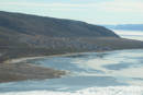
Byen ligger umiddelbart W for Inersussat (Kap Ackland) under den midterste af de tre bræer på S-siden af halvøen Piulip Nunaa. Større skibe ankrer på ca. 15 m dybde ca. 100 m før ankermærkebåkelinjernes skæringspunkt. Ankerpladsen har god holdebund og er undertiden skærmet af grundstødte isfjelde. Under anduvningen af ankerpladsen kan strandede isfjelde uden for ankerpladserne skjule ankermærkebåker m.m., således at de først kan ses efter passage af isfjeldene. I sådanne tilfælde kan det være gavnligt at kontakte havnen for at få oplysninger om liggeforholdene på ankerpladsen. Tankskibe og mindre togtefartøjer kan agterfortøje til en ringbolt på stenrøsen. Stenrøsen tæt under kysten er tør ved lavvande og dybden tiltager hurtigt til 5-7 m og er derefter ca. 15 m på ankerpladserne. Sejlløbet over stenrøsen til Landingsstedet er normalt afmærket med 4 røde plastbøjer, 2 på hver side af gennemsejlingen.
Dagens længde (ca. tider):
Mørketid: 3. november - 9. februar.
Midnatssol: 24. april - 18. august.
Manøvrefart.
Produktionsanlægget (ejerskab uvis) med tilhørende fryselager på ca. 20 tons og tørrelager, er den eneste reelle arbejdsplads ud over servicearbejdspladserne, men p.g.a. meget få og svingende tilførsler udnyttes anlægget meget dårligt eller slet ikke.
Der er normalt 2 skibsanløb med forsyninger samt et anløb af tankskib.
Herudover anløbes distriktet normalt af nogle mindre krydstogtsskibe.
Se havneskitse.
Bundforhold: Ankerplads: Klippe/ral.
Ingen.
Sundhedsvæsen:
Sundhedscenter, læge og tandlæge (periodisk) samt apotekervarer.
KNI Pilersuisoq A/S
Telefon (+299) 86 81 00 og (+299) 86 81 02
Telefax (+299) 97 11 44
Mobiltelefon (+299) 54 72 13
E-post: 170Qaanaaq@kni.gl
KNI Pilersuisoq A/S
Ved besejling af Nordvestgrønland samt Qaanaaq (Thule) distrikt kan Aasiaat Radio for det meste benyttes via MF-senderen i Upernavik på 3676 Khz.
Kommunikationen kan også ske via Aasiaat Radio (OYR) på HF.
Hvis ikke der kan nås forbindelse vedr. evt. Kystkontrol/Greenpos kan der telefoneres ind til Aasiaat Radio på følgende telefonnumre 130 eller +299 89 31 26 hvor man får kontakt med skibsvagten.
Der er V-Sat, SatB, SatC, Iridium samt mobildækning.
Der findes KNR TV og radio FM 95Mhz.
Standardordensreglement.
The harbour is owned by the Government of Greenland and is administered by KNI Pilersuisoq A/S. It consists of an anchorage outside the town. There is a long rocky point close to shore that is dry at low tide. Depending on the tide, barges can sail through the gap in the rocky point to the landing site on the beach. The passage can be used for approx. 3½ hours before and after high tide. Seabed conditions: Anchorage: Rock/pebbles. Landing site: Sand/pebbles.
Qaanaaq means "eroded cave in ice or on land". Qaanaaq (Thule) is the northernmost city of the hunting culture and the traditional Greenlandic lifestyle manifests itself today in a relatively "modern" town, because when the American air base in Thule (also called Dundas) was to be expanded in 1953, the original inhabitants were moved approx. 130 km to the north, where a whole new town Qaanaaq (Thule) was built.
Refer to the harbour sketch.
At anchor: Length 135 m, width 16.0 m, draught 7.0 m.
HW constant + 30 min on North Star Bugt. Tidal range at spring tide is approx. 3.0 m, and at neap tide approx. 1.7 m. Max. tidal range approx. 3.4 m.
In calm wind conditions, the tidal current flows WNW at 1-3 knots at the anchorage and is strongest 1-3 hours before high tide. At the passage to the landing site, the tidal current flows at 1-3 knots with a rising or falling tide.
In calm wind conditions, the tidal current flows WNW at 1-3 knots at the anchorage and is strongest 1-3 hours before high tide. At the passage to the landing site, the tidal currWinter ice normally prevents navigation from late September to early July. There is often heavy ice drift at the anchorage, but it is rarely necessary for ships to move because the shallow depths at the anchorage mean that only smaller ice bergs and floes can enter. Approx. 0.5-1 M from land, the depth decreases from 500 m to approx. 30 m depth. The ice drift moves S along the rocky point, where floes strand off the river estuary N of the anchorage. nt flows at 1-3 knots with a rising or falling tide.
Wind conditions are usually calm for most of the year, but very violent winds from SE and E can occur, almost without warning. The prevailing winds are usually mild. Fresh tidal winds can blow from SSE.
Fog occurs frequently in the summer, especially during the break-up of the winter ice in July.
The harbour can be navigated around the clock by people with local knowledge. Approach conditions and anchoring: The town is located immediately W of Inersussat (Kap Ackland) under the central glacier of the 3 glaciers on the S side of the peninsula Piulip Nunaa. Large ships anchor in a depth of approx. 15 m approx. 100 m before the intersection of the anchor beacon lines. The anchorage has good holding ground and is sometimes shielded by stranded icebergs. When approaching the anchorage, stranded icebergs outside the anchorage may conceal anchor beacons, etc., so that they can only be seen after passing the icebergs. In such cases, it may be advisable to contact the harbour to obtain information about the conditions in the anchorage. Tankers and small cruise vessels can stern-moor to a mooring ring on the rocky point. The rocky point near the coast is dry at low tide and the depth increases rapidly to 5-7 m and is then approx. 15 m at the anchorages. The channel to the landing site over the rocky point is usually marked with 4 red plastic buoys, 2 on each side of the channel.
Length of the day (approx. times): Polar night: 3 November - 9 February. Midnight sun: 24 April - 18 August.
Manoeuvre speed.
The production plant (ownership unknown) with associated cold-storage capacity of approx. 20 tonnes and drying facilities are the only real workplace other than the service workplaces, but due to very few and fluctuating supplies, the plant is used very little or not at all.
There are usually 2 calls by ships with supplies and a call by a tanker. The district is also usually visited by some small cruise ships.
Refer to the harbour sketch.
Seabed conditions: Anchorage: Rock/pebbles.
None. Health service: Health centre, doctor and dentist (occasional) as well as pharmacy products.
KNI Pilersuisoq A/S Telephone (+299) 86 81 00 and (+299) 86 81 02 Fax (+299) 97 11 44 Mobile telephone (+299) 54 72 13 E-mail: 170Qaanaaq@kni.gl
KNI Pilersuisoq A/S
When navigating Northwest Greenland and the Qaanaaq (Thule) district, Aasiaat Radio can mostly be used via the MF transmitter in Upernavik on 3676 Khz. Communication is also possible via Aasiaat Radio (OYR) on HF. If no connection can be achieved in connection with any Coastal Control/Greenpos, it is possible to telephone to Aasiaat Radio on the following telephone numbers 130 or +299 89 31 26, where you can get in touch with the duty officer. There is V-Sat, SatB, SatC, Iridium and mobile coverage. KNR TV and radio FM 104.0 Mhz can be received.