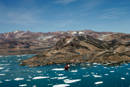
Tunu (Østgrønland)
70°28,967'N 021°58,011'W - Kort 2600 - havneplanskort 2650
Tunu (East Greenland)
70°28,967'N 021°58,011'W - Chart 2600 - harbourplan chart 2650
By
328 indbyggere (2026)
City
328 inhabitants (2026)
der ejes af Grønlands Selvstyre og administreres af KNI Pilersuisoq A/S, er beliggende i den NE-lige del af Rosenvinge Bugt og består af 2 S-vendte vige med et par ankerpladser ud for byen.
Den V-lige vig, Hospital Bugt, anvendes af det årlige tankskib, der agterfortøjer ud for tankanlægget. Den E-lige vig bruges ved de 2 årlige anløb af forsyningsskibet.
Pramlosningsbro fra 1999/2000 er beliggende lige W for elvlejet og dæmningen, der kun bruges til joller o.l.
Kajlængde 6 m / Dybde oprindeligt 3,5 m men for tiden ukendt (2019) / Bolværkshøjde ca. 2 m. Der pramlosses på stranden umiddelbart W for pramlosningsbroen (2019)
Der kan etableres pontonbro til brug for tenderoperation.
Bundforholdene på ankerpladsen er klippe/sten og holdebunden er nogenlunde.
Illoqqortoormiut (vest-grl.) Ittoqqortoormiit (øst-grl.) betyder "Folkene, der bor ved de store huse".
Byen, eller kolonien, blev oprettet af Ejnar Mikkelsen i 1924, hvor de første bygninger blev opført. Det var dog ikke den planlagte placering, man fik, idet ekspeditionsskibet "Grønland" fik rorhavari og kunne derfor ikke komme ind til Ujuaakajiip Nunaa (Danmark Ø) længere inde i fjordsystemet, hvor det var planlagt, at den nye koloni skulle ligge. Man måtte så, grundet det sene tidspunkt på året, anlægge kolonien, hvor den ligger nu lige ved Ittoqqortoormiit Kimmut Kangertivat (Amdrup Havn). Det danske flag blev rejst den 7. august 1924.
I 1925 kom så 82 personer (4 familier) fra Tasiilaq med skib til stedet. De var på Ejnar Mikkelsens foranledning (grundet hungersnød i Tasiilaq-distriktet) blevet flyttet hertil, Det er så senere blevet til en by på ca. 575 personer, da den var på sit højeste. Nu (2013) er der kun 452 beboere.
Den første kolonibestyrer var "Ujuaat", Johan Petersen, som Ejnar Mikkelsen flyttede fra Tasiilaq til den nyoprettede koloni.
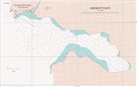
Se havneplan.
til ankers: m/s "Malik Arctica", længde 114,4 m, bredde 22,7 m, dybgang 8,21 m..
HW-konstant: Uunarteq (Kap Tobin)
Flodhøjde ved springtid ca. 2,0 m, ved niptid ca. 1,8 m.
I selve Kangertittivaq (Scoresby Sund) fjordsystemet er der tidevandsstrøm samt en kraftig understrøm, der fører de store isfjelde ud af fjorden med en fart af 0,5 til 1,5 knob. Ved Kangikajik (Kap Brewster) går strømmen i S- og SE-lig retning.
Ved ankerpladsen er strømmen for det meste W-gående ud fra Ittoqqortoormiit Kimmut Kangertivat (Amdrup Havn) og langs kysten mod byen og sammen med strømmen fra elvudløbet kan der stå en forholdsvis kraftig strøm.
Hvis storisen forsvinder fra mundingen af fjordsystemet, er der frit løb for sø og dønning. Det kan blive så voldsomt, at pramlosning/-lastning må stoppes.
Strøm fra elvudløbet E for molehovedet er mærkbar tæt ved molen og bevirker, at isen under rolige vejrforhold presses S om ankerpladsen. Overfladestrømme er stærkest fra primo august til primo oktober.
Isfri anløbsperiode: Ultimo juli - medio september.
Vinterisen lukker for besejling fra ultimo september til juli. DMI's Istjeneste bør altid kontaktes før anløb. Hvad angår den generelle beskrivelse af isforholdene i området, henvises til Den grønlandske Lods.
Is ved ankring:
Under ankring er der ingen læ for drivisen, da der går en stærk overfladestrøm langs kysten af S-lige del af Liverpool Land. Denne strøm fører drivis med sig ind i Ittoqqortoormiit Kimmut Kangertivat (Amdrup Havn) og videre ud igen forbi Illoqqortoormiut (Scoresbysund) ud i Rosenvinge Bugt og over mod Noorajik Kangitteq (Kap Hope). Fra primo juli til ultimo september vil der normalt være mulighed for at komme ind i Ittoqqortoormiit Kimmut Kangertivat (Amdrup Havn).
Store isfjelde kan på grund af det læge vand ikke komme ind i havnen, men drivis og mindre skosser kan ofte blokere den. Fox Havn 70º27´'N 021º56'W er den lille vig S for Ittoqqortoormiit Kimmut Kangertivat (Amdrup Havn). Små fartøjer kan her finde læ for isen. Havnen skal anduves i indløbets S-side, da der er skær ved N-siden.
Der kan stå friske fjord- og tidevandsvinde overalt i fjordsystemet. Den mest fremherskende vind kommer fra N, og kan nå orkanstyrke meget hurtigt.
Kan ligge meget tæt og lavt over hele storisområdet ud til iskanten. Megen is i fjordsystemet forårsager meget aften- og nattetåge.
I august/september letter tågen gerne i løbet af formiddagen.
Ved lavtrykspassager ud for mundingen kommer der megen nedbør og dermed ringe sigtbarhed.
Havnen kan anløbes døgnet rundt.
Den mest almindelige anduvning af Kangertittivaq (Scoresbysund Fjord) systemet er direkte E fra på ca. 70°25'N bredde, og der holdes direkte mod Uunartip Nuua (Kap Tobin).
I særlige gunstige isår kan der være en del landvand inde under Blossevillekyst fra 68°N og N over mod Kangikajiiip Appalia (Kap Brewster). Med helt friske iskort og vejrkort kan man med fordel gå igennem isen her, og så sejle op indenfor storisen.
Dette var muligt i 2000 og 2006 med godt resultat, men det har kun kunnet lade sig gøre 4 til 5 gange indenfor de sidste 20 år. Muligheden for at blive fanget af isen ved kraftig NØ-lig vind er til stede, og derfor skal anduvningen her bruges med stor forsigtighed.
I både 2009 og 2011 blev begge måder benyttet med held.
Der ankres ca. 0,2 sm i pejling 215° fra brohovedet på ca. 30 meters dybde med 4 sjækler i vandet.
Dagens længde (ca. tider):
Mørketid: 20. november - 23. januar.
Midnatssol: 16. maj - 28. juli.
Manøvrefart under sejlads i havnen.
Byen har ikke noget egentlig indtægtsgrundlag. Der indhandles lokalt til den lille stedlige fabrik ca. 2000 sælskind og 20 til 30 isbjørneskind samt ca. 30 tons moskusoksekød årligt.
Byen forsynes normalt med 2 årlige anløb af forsyningsskibet samt et anløb af olietankskib.
Se havneplan.
Det kan ikke forventes i hele Østgrønland, at båker er på plads og i orden, da de ikke bliver vedligeholdt og repareret. Båkerne var i 2019 ikke på plads og i orden.
Større skibe ankrer på ca. 30 m vand ca. 350 m fra land lidt W for ankermærkerne, hvis ellers de er i orden, ellers må der ankres efter pejling og afstand til land.
Der kan agterfortøjes til forskellige pullerter rundt i den V-lige side af bugten, men man skal kun gøre det under meget rolige vejrforhold. Man skal i særdeleshed være opmærksom på, at isen kommer drivende meget hurtigt. I særlige tilfælde under på ½ time fra Uunartip Nuua (Kap Tobin) til Illoqqortoormiut (Scoresbysund).
Pludselige E- , S- og W- opfriskende vinde kan give en meget kraftig isgang på ankerpladsen. Ispresset kan blive så stort, at afsejling ikke er mulig. Det skete i 1982 for m/s Nanok S, der lå agterfortøjet og ikke fik flyttet sig i tide. Skibet lå i over 2 døgn med maskinen på fuld kraft frem for ikke at drive eller blive presset på land.
Hospitalsvig bliver kun brugt af det årlige tankskib, der agterfortøjer under samme hensyntagen som ovenfor.
Det tilrådes derfor, at maskinen altid er på "meget kort opstart", og at der konstant gåes ankervagt.
Nødankerplads:
I Ittoqqortoormiit Qinngerajivat (Hvalrosbugt) kan større skibe ankre i den NE-lige del på ca. 40 m vand ca. 0,5 sm fra land på positionen ca. 70°29,6'N 021°59,3'W, og mindre fartøjer kan ankre på ca. 20 m vand ca. 500 m fra land NNE for ovennævnte position.
Holdebunden er god og består af sand/ler. Der er læ for alle vinde med undtagelse af SW-lige.
Ittoqqortoormiit Qinngerajivat (Hvalrosbugt) er ikke opmålt, men det vides, at 10 m kurven forløber omtrent parallelt med kysten i ca. 250-500 m afstand af land. I den E-lige del af bugten ligger 10 m kurven nærmest land, og mellem Illoqqortoormiut (Scoresbysund) og den tidligere vejrstation ved bugtens NE-lige del er dybden over 10 m i ca. 50 m afstand fra kysten. 100 m kurven forløber fra ca. 1,5 sm SW for Illoqqortoormiut (Scoresbysund) i WSW-lig retning til ca. 2 sm SE for Aamarsuit Nuuat (Basaltnæs). Ud for Aamarsuit Nuuat (Basaltnæs) strækker en sandbanke med ca. 10 m dybde sig ca. 2 sm mod SE. Bugten er ren uden for 10 m kurven, men med noget varierende dybder, og mindst dybde i den NW-lige del, hvor der er sandbund.
Ankerpladsen kan benyttes af større skibe fra primo juli til ultimo september, da vinterisen normalt bryder op primo juli.
Se ældre nødkort fra US. Marine fra 1946.
Ittoqqortoormiit Kimmut Kangertivat (Amdrup Havn) er en god ankerplads for mindre skibe, men holdebunden er ikke god, da den mest består af klippe/sten.
Der findes hverken lods eller kendtmand. Oplysninger om isforholdene ved byen kan indhentes hos havnemyndighederne.
Ingen.
Losse- og lastegrej:
1 pramkran med løfteevne på 9 tons. 2 pramme med bæreevne på 10 tons. 2 vognpramme med bæreevne på 6 tons. 2 trucks (3 tons) og en ladvogn (3 tons).
Sundhedsvæsen:
Sundhedscenter, læge og tandlæge samt apotekervarer og håndkøbsudsalg. Mulighed for anskaffelse og supplering af "medicinkiste".
KNI Pilersuisoq A/S
Telefon (+299) 86 84 45 og (+299) 86 84 46
Telefax (+299) 99 10 50
Mobiltelefon (+299) 59 91 40
E-post: 190Ittoqqortoormiit@kni.gl
Kommunikation med omverdenen:
Ved besejling af Nordøstgrønland kan Aasiaat Radio muligvis bruges på HF, ellers er den eneste kommunikation på StdC. , StdB. V-Sat og Iridium nord for Ittoqqortoormiit (Scoresbysund).
Der findes radio FM 96,00 Mhz og TV, der sender KNR.
Standardordensreglement.
The harbour is owned by the Government of Greenland and administered by KNI Pilersuisoq A/S. It is located in the NE part of Rosenvinge Bugt and consists of 2 S-facing coves with a pair of anchorages off the town.
The W cove, Hospital Bugt, is used by the annual tanker, which stern-moors off the tank installation. The E cove is used for the 2 annual calls by the supply ship.
A Barge unloading pier from 1999/2000 is located just W of the river estuary and the sea wall, which is only used for dinghies etc.
Quay length 6 m/depth originally 3.5 m but currently unknown (2019) /wharf height approx. 2 m.
Barge unloading is possible on the beach W of the Barge unloading pier (2019).
A pontoon bridge can be established for tender operations.
The seabed conditions at the anchorage are rock/stones and the holding ground is reasonable
Illoqqortoormiut (West-Greenland) Ittoqqortoormiit (East-Greenland) means "The people who live by the big houses".
The town, or colony, was established by Ejnar Mikkelsen in 1924, when the first buildings were constructed. However, this was not the location that was originally planned. The expedition ship "Greenland" suffered a rudder failure and was therefore unable to reach Ujuaakajiip Nunaa (Danmark Ø) further inside the fjord system, where the new colony was intended to be located. Due to the late time of the year, the colony had to be built where it is now located, just off Ittoqqortoormiit Kimmut Kangertivat (Amdrup Havn). The Danish flag was hoisted on 7 August 1924.
82 people (4 families) arrived there by ship from Tasiilaq in 1925. They were moved here at the request of Ejnar Mikkelsen (due to famine in the Tasiilaq district). It subsequently developed into a town of 575 people when it was at its peak. There are now (2013) 452 residents.
The first colony manager was "Ujuaat", Johan Petersen, who Ejnar Mikkelsen moved from Tasiilaq to the newly created colony.
Refer to the harbour plan.
At anchor: M/S "Malik Arctica", length 114 m, width 22.7 m and draught 8.21 m.
HW constant: Uunarteq (Kap Tobin)
Tidal range at spring tide approx. 2.0 m, at neap tide approx. 1.8 m.
The Kangertittivaq (Scoresby Sund) fjord system itself has a tidal current as well as a strong undercurrent that carries the large icebergs out of the fjord at a rate of 0.5 to 1.5 knots. The current at Kangikajik (Kap Brewster) flows in a S and SE direction.
The current at the anchorage mostly flows W out from Ittoqqortoormiit Kimmut Kangertivat (Amdrup Havn) and along the coast towards the town and, combined with the current from the river estuary, it can be relatively strong.
If the polar ice disappears from the mouth of the fjord system, the fjords are open to waves and swell. These can be so violent, that the loading and unloading of barges must be stopped.
The current from the river estuary E of the pier is noticeable at the pier and, under calm weather conditions, it causes the ice to be pushed S around the anchorage. Surface currents are strongest from early August to early October.
The Kangertittivaq (Scoresby Sund) fjord system itself has a tidal current as well as a strong undercurrent that carries the large icebergs out of the fjord at a rate of 0.5 to 1.5 knots. The current at Kangikajik (Kap Brewster) flows in a S and SE direction.
The current at the anchorage mostly flows W out from Ittoqqortoormiit Kimmut Kangertivat (Amdrup Havn) and along the coast towards the town and, combined with the current from the river estuary, it can be relatively strong.
If the polar ice disappears from the mouth of the fjord system, the fjords are open to waves and swell. These can be so violent, that the loading and unloading of barges must be stopped.
The current from the river estuary E of the pier is noticeable at the pier and, under calm weather conditions, it causes the ice to be pushed S around the anchorage. Surface currents are strongest from early August to early October.
Ice when at anchor:
There is a strong surface current along the coast of the S part of Liverpool Land and therefore there is no protection from drift ice while at anchor. This current brings drift ice into Ittoqqortoormiit Kimmut Kangertivat (Amdrup Havn) and further out again past Illoqqortoormiut (Scoresbysund), out into Rosenvinge Bugt and over towards Noorajik Kangitteq (Kap Hope).
It is normally possible to get into Ittoqqortoomiit Kimmut Kangertivat (Amdrup Havn) froem early-July until the end of September. Due to the shallows water, large icebergs cannot get into the harbor, but it is often blocked by drift ice and smaller growlers. Fox Havn 70º27'N 021º56'W is a small cove S off Ittoqqortoomiit Kimmut Kangertivat (Amdrup Havn). Small vessels can find shelter from the ice here. The harbor must be approached from the S side of the entrance, as there are rocks on the N side.
Fresh fjord and tidal winds can blow everywhere in the fjord system. The most prevalent wind is from N and can reach hurricane strength very quickly.
Very dense and low fog can occur everywhere in the polar ice area out to the ice edge. Evening and night-time fog can occur when there are large quantities of ice in the fjord system. In August/September, the fog usually dissipates during the morning. Depressions passing by the mouth of the fjord system produce a lot of precipitation and thus poor visibility.
The harbour can be navigated around the clock.
The most common approach to the Kangertittivaq (Scoresbysund Fjord) system is direct E from approx. 70°25'N latitude and then steering directly towards Uunartip Nuua (Kap Tobin).
In particularly favourable ice years, there may be some shore lead under Blossevillekyst from 68°N and northwards towards Kangikajiiip Appalia (Kap Brewster). With completely new ice charts and weather maps, it is advisable to pass through the ice here, and then navigate up inside the polar ice.
This was possible in 2000 and 2006 with good results, but it has only been possible 4-5 times in the last 20 years. There is a possibility of being trapped by the ice in strong NE winds, and this approach must therefore be used with extreme caution.
Both routes were used successfully in 2009 and 2011.
Ships can anchor approx. 0.2 M on a bearing of 215° from the pier in approx. 30 m of water with 4 shackles in the water.
Note the comment on tanker approach.
Length of the day (approx. times):
Polar night: 20 November - 23 January.
Midnight sun: 16 May - 28 July
Manoeuvre speed when navigating in the harbour.
The town has no actual income base. Purchasing is performed locally for the small local factory and comprises approx. 2,000 sealskins, 20-30 polar bear skins and approx. 30 tonnes of muskox meat annually.
The town is usually supplied by 2 annual calls by the supply ship and one call by an oil tanker.
Refer to the harbour plan. It cannot be expected throughout East Greenland that beacons are in place and in working order, as they are not maintained and repaired. The beacons was not in place and in working order in 2019.
Large ships anchor in approx. 30 m of water approx. 350 m from land a little W of the anchor mark beacons, if they are in order. Otherwise, ships must anchor according to a bearing and distance to land.
Ships can stern-moor to various bollards in the W part of the bay, but only in very calm weather conditions. It is important to be aware that the ice can drift very quickly. In certain circumstances, less than 30 minutes from Uunartip Nuua (Kap Tobin) to Illoqqortoormiut (Scoresbysund).
Sudden fresh winds from E, S and W can produce very strong ice drift at the anchorage. The pressure on the ice can become so strong that navigation becomes impossible. This occurred in 1982 for M/S Nanok S, which was stern-moored and failed to move in time. The ship was trapped for 2 days with its engine at full speed ahead in order not to drift or be pushed ashore.
Hospitalsvig is only used by the annual tanker, which stern-moors with the same precautions as above.
It is therefore advisable to have the engine on very short stand-by and to keep a constant anchor watch.
Emergency anchorage:
In Ittoqqortoormiit Qinngerajivat (Hvalrosbugt), large ships can anchor in the NE part in approx. 40 m of water, approx. 0.5 M from shore at position approx. 70°29.6'N 021°59.3'W, and smaller vessels can anchor in approx. 20 m of water, approx. 500 m from shore, NNE of the position mentioned above.
The holding ground is good and consists of sand/clay. The anchorage provides shelter from all winds except SW.
Ittoqqortoormiit Qinngerajivat (Hvalrosbugt) has not been surveyed, but it is known that the 10 m contour line runs approximately parallel to the coast at a distance of approx. 250-500 m from shore. In the E part of the bay, the 10 m contour lies closest to the land. Between Illoqqortoormiut (Scoresbysund) and the former weather station in the NE part of the bay, the depth exceeds 10 m at a distance of approx. 50 m from the coast. The 100 m contour line extends from approx. 1.5 M SW of Illoqqortoormiut (Scoresbysund) in a WSW direction to approx. 2 M SE of Aamarsuit Nuuat (Basaltnæs). A sandbank extends SE from off Aamarsuit Nuuat (Basaltnæs) at a depth of approx. 10 m for approx. 2 M. The bay is free of dangers outside the 10 m contour line, but with somewhat varying depths. The shallowest depths are in the NW part, where there is a sandy bottom.
The anchorage can be used by large ships from early July to late September, as the winter ice usually breaks up in early July.
See older emergency charts from US Marine from 1946.
Ittoqqortoormiit Kimmut Kangertivat (Amdrup Havn) is a good anchorage for smaller ships, but the holding ground is not good as it consists mostly of rock/stone.
There is no pilot or person with local knowledge. Information about the ice conditions at the town can be obtained from the harbour authorities.
None.
Loading and unloading gear:
1 barge crane with lifting capacity of 9 tonnes. 2 barges with lifting capacity of 10 tonnes. 2 vehicle barges with lifting capacity of 6 tonnes. 2 trucks (3 tonnes) and a flat-bed truck (3 tonnes).
Health service:
Health centre, doctor and dentist as well as pharmacy products and over-the-counter medicine. Possibility of procurement and supplementation of "medicine chest".
KNI Pilersuisoq A/S
Telephone (+299) 86 84 45 and (+299) 86 84 46
Fax (+299) 99 10 50
Mobile telephone (+299) 59 91 40
E-mail: 190Ittoqqortoormiit@kni.gl
Communication with the external environment:
When navigating North-east Greenland, it may be possible to use Aasiaat Radio on HF. Otherwise, the only communication is on StdC, StdB, V-Sat and Iridium north of Ittoqqortoormiit (Scoresbysund).
There is radio FM 96.00 Mhz and TV that broadcasts KNR