Kujataa (Sydgrønland)
60°08,935'N 044°17,275'W - Kort 1103 - havneplanskort 1150
Kujataa (South Greenland)
60°08,935'N 044°17,275'W - Chart 1103 - harbourplan chart 1150
Bygd
81 indbyggere (2026)
Settlement
81 inhabitants (2026)
der ejes af Grønlands Selvstyre og administreres af KNI Pilersuisoq A/S, består af en meget smal S-vendt havnevig med et brohoved.
Brohoved: Kajlængde 5 m/ Dybde 1) 0,3-2,5 m/ Bolværkshøjde 2) 1,0 m/ Belastning 800 kg/m².
Bundforhold: Klippe.
1) middelspringtidslavvande, 2) middelhøjvande.
Aappilattoq betyder på grønlandsk "rødligt sted".
Bygden har været beboet siden 1800-tallet, men blev grundlagt som handelsstation i 1922 ifm. indhandlingscentraliseringen af fisk i Nunap Isua (Kap Farvel) området.
Ikerasassuaq (Prins Christian Sund) Vejrstation ligger ca. 65 km øst for bygden.
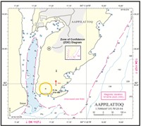
Se havneplan samt havneskitse.
Langs brohovedet og ved højvande, bygdeforsyningsskibet (længde 30 m, bredde 9 m og dybgang 3 m).
m/s "Pajuttaat" (længde 63 m, bredde 12 m og dybgang 3,5 m) har været ved brohovedet enkelte gange ved højvande og stille vejr.
Bygdetankskibet på op til:
Længde 77 m, bredde 13,5 m og dybgang 4,5 m, ligger agterfortøjet på 7-11 m vand S for brohovedet.
Flodhøjde ved springtid ca. 3,0 m, ved niptid ca. 1,5 m. Maks. flodhøjde ca. 3,5 m.
Tidevandsstrømmen i sundet ud for Aappilattoq sætter stærkt E-over ved stigende vande og W-over med tilsvarende styrke ved faldende vande. I havnevigen mærkes tidevandsstrømmen næsten ikke, dog bevirker idvandet i det smalle havneløb, at der her opstår strømhvirvler.
Isfri anløbsperiode: Juli - maj.
I storisperioden maj - august kan havneindløbet være spærret af is. Bræis og mindre isfjelde kan hele året genere besejling af havnen. Vinteris dannes kun i havnevigens N-lige del. I vinterperioden dannes en svær isfod rundt hele havnevigens klippekyst samt i indsejlingen.
De hyppige lavtrykspassager i området forårsager kraftige fjeldkast fra de høje og stejle fjelde på havnevigens W-side. De friske tidevands- og fjordvinde gennem sundet kan mærkes i bygden.
Da der forekommer pludselige fjeldkast ved lavtrykspassager, anbefales det kun at agterfortøje under særdeles gode vejrforhold. Af samme årsag frarådes det større skibe at ligge natten over i havnen. Dette gælder især i efterårs- og vinterperioden, hvor fjeldkastene og fjordvindene kan nå orkanagtig styrke. På grund af dette kan havnen i disse perioder ikke regnes for sikker liggeplads.
Der er sjældent tåge i området, men S- og SE-lige vinde giver som oftest nedbør og ringe sigt.
Havnen kan kun besejles om dagen.
Anløbsforhold og ankring:
Der er grundt vand i havnevigens W-lige del samt i indsejlingens E-lige side, hvorfor der skal holdes i W-lige side af løbet med god manøvrefart på grund af strømhvirvler samt under hensyntagen til idvande. Mindre skibe fortøjer langs brohovedet (nokken), mens større skibe enten agterfortøjer S herfor, ligger til ankers. Ringbolte findes på begge sider af havnen.
Dagens længde (ca. tider):
Korteste dag: 0900-1500.
Længste dag: 0200-2300.
Styrefart under sejlads i havnen.
Der er et produktionsanlæg for fisk i bygden og dette er i drift i 2014 efter at have ligget stille i nogle år.
Der indhandles især hellefisk og havkat.
Herudover kommer der nogle turister herunder bjergbestigere, der klatrer på de høje og stejle fjelde i hele Ikerasassuaq (Prins Christian Sund) området.
Bygden forsynes jævnligt af Royal Arctic Lines bygdeskib i Sydgrønland og der er ugentlig helikopterforbindelse til omverdenen (hvis vejret tillader).
Nødankerplads: Kangikitsoq, hvor der ankres i bunden af fjorden på 30-35 m vand. Ankerpladsen, der er en af de bedste i den S-lige del af Grønland, giver læ for alle vinde og har en særdeles god holdebund bestående af en blanding af ler, sand og grus. W for elvdeltaet og i ankervigens NW-lige del er der urent. Ved elvlejet ud for 66 m-lodskuddet findes en "tærskel" tværs over fjorden.
Ferskvand kan fyldes fra elven i havnens W-side. Gasolie og proviant kan ikke påregnes.
Losse- og lastegrej:
2 søjlekraner med løfteevne på 1 ton. 1 traktor med anhænger. Lasteevne 2 ton.
Sundhedsvæsen:
Bydesundhedsarbejder.
KNI Pilersuisoq A/S
Telefon (+299) 86 83 81 og (+299) 86 83 82
Telefax (+299) 61 76 88
Mobiltelefon (+299) 49 27 62
E-post: 012@kni.gl
I bygden findes KNR TV samt FM 95,5 Mhz.
VHF kanal 28 kan bruges til kontakt med Aasiaat radio.
Standardordensreglement.
The harbour is owned by the Government of Greenland and is administered by KNI Pilersuisoq A/S. It consists of a very narrow, S-facing harbour cove with a pier. Pier: Quay length 5 m/depth 1) 0.3-2.5 m/wharf height 2) 1.0 m/load 800 kg/m2.
Seabed conditions: Rock.
1) Mean low water spring, 2) Mean high tide.
Aappilattoq means "reddish place" in Greenlandic.
The settlement has been inhabited since the 19th century, but was established as a trading station in 1922 in connection with the centralisation of the purchasing of fish in the Nunap Isua (Kap Farvel) area.
Ikerasassuaq (Prins Christian Sund) Weather Station is located approx. 65 km E of the settlement.
Refer to the harbour plan and harbour chart.
Along the pier and at high tide, the settlement supply ship (length 30 m, width 9 m and draught 3 m) and the m/s "Pajuttaat" (length 63 m, width 12 m and draught 3.5 m) has been at the pier occasionally during high tide and in calm weather.
The settlement tanker of up to: Length 77 m, width 13.5 m and draught 4.5 m, lies stern-moored in 7-11 m of water S of the pier.
Tidal range at spring tide approx. 3.0 m, at neap tide approx. 1.5 m. Max. tidal range approx. 3.5 m.
The tidal current in the sound off Aappilattoq flows strongly E with rising tides and W with similar strength with falling tides. The tidal current is barely noticeable in the cove, but the coastal countercurrent in the narrow harbour channel causes eddies to occur here.
Ice-free approach period: July - May.
The harbour entrance may be blocked by ice during the polar ice period from May to August. Glacial ice and small icebergs can impede navigation of the harbour throughout the year. Winter ice only forms in the N part of the harbour. During the winter period, a heavy ice foot forms around the entire rocky coast of the cove and in the entrance.
The frequent occurrence of low-pressure systems in the area causes strong mountain gusts from the high and steep mountains on the W side of the cove. The fresh tidal and fjord winds through the sound can be felt in the settlement.
Sudden mountain gusts arise in connection with passing depressions, so it is recommended to stern-moor only during particularly good weather conditions. For the same reason, it is not advisable for larger ships to remain overnight in the harbour. This is especially true during the autumn and winter period, when the mountain gusts and fjord winds can reach hurricane-like strength. Therefore, the harbour cannot be considered a safe berth during these periods.
There is rarely fog in the area, but S and SE winds usually give precipitation and poor visibility.
The harbour can only be navigated during the day.
Approach conditions and anchoring:
There is shallow water in the W part of the cove, as well as on the E-side of the entrance, so keep to the W side of the channel with good navigable speed due to eddies, while taking account of the coastal countercurrent. Smaller ships moor along the pier (the pierhead), while larger ships either stern-moor S of here or ride at anchor. Mooring rings are available on both sides of the harbour.
Length of the day (approx. times): Shortest day: 09:00-15:00. Longest day: 02:00-23:00.
Manoeuvre speed during navigation in the harbour.
There is a production plant for fish in the settlement and this was in operation in 2014, after lying dormant for a number of years. Halibut and catfish in particular are purchased. Some tourists also visit here, including mountaineers who climb the high and steep mountains throughout the Ikerasassuaq (Prins Christian Sund) area.
The settlement is provisioned regularly by Royal Arctic Line's settlement ship in South Greenland and there is a weekly helicopter connection to the outside world (weather permitting).
Emergency anchorage: Kangikitsoq, where it is possible to anchor in the bottom of the fjord in 30-35 m of water. The anchorage, which is one of the best in the S of Greenland, provides shelter in all winds and has a very good holding ground consisting of a mixture of clay, sand and gravel. The waters are foul W of the river delta and in the NW part of the anchorage cove. There is a "threshold" across the fjord at the riverbed off the 66 m sounding.
Fresh water can be obtained from the river on the W-side of the harbour. Gas oil and provisions cannot be expected.
Loading and unloading gear:
2 tower cranes with lifting capacity of 1 tonne. 1 tractor with trailer. Load capacity 2 tonnes.
Health service:
Settlement health worker.
KNI Pilersuisoq A/S
Telephone (+299) 86 83 81 and (+299) 86 83 82
Telefax (+299) 61 76 88
Mobile telephone (+299) 49 27 62
E-mail: 012@kni.g
The settlement receives KNR TV and FM 95.5 Mhz.
VHF channel 28 can be used to contact Aasiaat radio